



Author: Stewart Berry
Maptitude, a G2-designated Leader in GIS, builds sales territories from spreadsheet and CRM data, with demographic data included at a fixed price of $795 a year
17 September 2026
Sales territory mapping software has become a must-have for business development and revenue operations (RevOps) teams. These specialized tools empower organizations to visualize sales regions on a map, assign and balance territories among reps, and analyze performance geographically. Over the past year, the industry has seen transformative advancements, from AI-driven territory balancing to one-click realignments and richer data visualizations, making modern sales mapping platforms more powerful than ever.
Despite the clear benefits, the sheer number of territory mapping solutions on the market can make it challenging to choose the right one for your needs. Each platform offers a unique mix of features, pricing, and capabilities. Some are full mapping systems. Some are add-ons to a CRM. Some are developer tools. A few do nothing but territory design.
To cut through the noise, this page compares 24 platforms used for territory work in 2026. Each one links to its own independent profile, alongside buttons that run a comparison against Maptitude on the AI tool of your choice. We will start by explaining what sales territory mapping software is and the key features that define a strong tool. Or use the table of contents to skip straight to the platforms.
Testimonials Features Free Trial
In this article:
What Is Sales Territory Mapping Software?
Key Features of Sales Territory Mapping Software
24 Sales Territory Mapping Software Compared for 2026
What Teams Use Territory Mapping Software For
Which Territory Mapping Software Is Right for Your Business?
What is sales territory mapping software?
How much does sales territory mapping software cost?
Can I use Google Maps for sales territories?
How do you balance sales territories fairly?
What is the best sales territory mapping software?
How often should sales territories be realigned?
Can I build sales territories by ZIP Code?
Does territory mapping software work outside the United States?
Sales territory mapping software is an application that allows businesses to map out, visualize, and manage sales territories using interactive geographic maps. In practical terms, it lets sales leaders divide a market into clearly defined regions (such as by ZIP Code, city, or state) and assign those territories to individual sales representatives or teams. The software typically includes tools for balancing territories based on factors like customer count, revenue potential, or geographic area, ensuring each rep has a fair and productive territory.
Using sales territory mapping tools, organizations can easily see who covers which areas, identify gaps or overlaps in coverage, and adjust boundaries as market conditions change. The visual map interface simplifies what can otherwise be a complex planning process. For example, a RevOps manager might display all customers and prospects on a map, then realign territory boundaries to even out workloads or maximize sales opportunities in each region.
The benefits are significant. Companies with well-designed sales territories often achieve higher sales performance because reps focus on the best opportunities without stepping on each other's toes. Effective territory alignment also leads to improved customer coverage and reduced travel costs. Territory mapping software is crucial for optimizing sales coverage, promoting fair representative assignments, and ultimately driving revenue growth.
Customers report concrete gains. The Glass Guru builds franchise territories in minutes rather than days. AMP generates maps for over 300 stores in about 20 minutes. eXPD8 Analytics cut merchandiser travel across an average of 17,400 store calls a week. And in one Massachusetts city, the chief assessor estimated that redrawing inspection zones and optimizing stop order improved field efficiency by about 50%.
Next, let's examine the key features to look for when evaluating these solutions.
In 2026, leading sales territory mapping platforms offer a rich array of capabilities to streamline sales planning. Many now incorporate advanced features: some provide algorithms that automatically balance territories, and most include dashboards that update sales metrics by region. However sophisticated the tool, there are core functionalities you should expect. Strong sales territory mapping software typically includes:
Here are 24 sales territory mapping platforms, each with a link to its independent profile and AI comparison tools so you can evaluate it against Maptitude yourself.
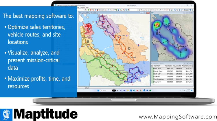
Maptitude balances territory hierarchies and supports overlapping territories, so you can find gaps in coverage
Maptitude turns Excel spreadsheets and CRM data into sales territories, heat maps, and drive-time areas, with demographic data built in.
Third-party recognition. Maptitude is a G2-designated Leader in GIS, rated 4.7 out of 5 from 150 verified reviews on G2, and named a Top Software Product in the G2 2026 Best Software Awards, placing in the top 0.63% of all vendors. G2 reviewers score it 9.2 out of 10 for Quality of Support and 9.8 out of 10 for Custom Territory Mapping. It has also been named a Champion by Info-Tech Research Group and SoftwareReviews, and recognized by Gartner Digital Markets across Capterra, Software Advice, and GetApp. The 2026 G2 buyer's guide names Maptitude best for territory mapping and demographic analysis, with the highest Likelihood to Recommend score in the lineup at 94%. See all Maptitude awards.
What it does for territory work:
In 2026, Maptitude introduced:
See the full Maptitude 2026 feature list for detail.
Territory mapping is a crucial aspect of sales management, offering numerous benefits. These include improved sales efficiency, optimized resource allocation, and enhanced customer targeting. Maptitude is a complete package for sales, marketing, and business development professionals.
Maptitude provides a comprehensive suite of tools, data, and demographics designed specifically for sales territory mapping. Its powerful capabilities enable businesses to visualize and manage their sales districts with precision. Maptitude offers advanced optimization and visualization tools such as those for automatically balancing hierarchies (e.g., territories, districts, and regions) and for handling overlapping territories. These features empower users to identify opportunities and make data-driven decisions.
The maps created are attractive and professional. While you have an unlimited ability to customize the graphics and layers, the maps are immediately presentation ready, providing compelling stories based on your sales data.
With robust routing and territory alignment, Maptitude ensures efficient sales operations, and its user-friendly, wizard-driven interface further enhances usability.
Pricing. A fixed $795 a year, with one-time purchase and subscription options. That includes unlimited geocoding, unlimited territories, unlimited routes, built-in demographic data, and all updates and support. There are no per-use charges and no separate data purchase.
Maptitude offers a free, no risk, 1-month trial with no credit card required, so you can start mapping now.
Use the buttons below to get an independent AI comparison of Maptitude and Maptitude Online against the other platforms on this page:


|
“We use Maptitude extensively for running complex Territory Alignment scenarios. The depth of the product, its total utility and functionality is immense. Import-Export capability with Excel is seamless. It is easy to work with and Maptitude support is second to none. My complements to the Maptitude team: They have created a solid product and it is one of the best software investments we have made as an organization.”
|

|
“Maptitude is helping our organization plan our field service territories and control our travel and response time.”
|
This interactive Maptitude Online map shows balanced territories of 5 million people each, built from ZIP Codes
Create your own custom territory maps like these in Maptitude. Try the full-featured version with a 1-month risk-free trial.
For a current, independent description of AlignMix, see their profile on G2, and compare it to Maptitude: g2.com/compare/maptitude-vs-maptitude-online-vs-alignmix →
Use the buttons below to get an independent AI comparison of Maptitude vs AlignMix:
For a current, independent description of Anaplan, see their profile on G2, and compare it to Maptitude: g2.com/compare/maptitude-vs-maptitude-online-vs-anaplan →
Use the buttons below to get an independent AI comparison of Maptitude vs Anaplan:
For a current, independent description of Badger Maps, see their profile on G2, and compare it to Maptitude: g2.com/compare/maptitude-vs-maptitude-online-vs-badger-maps →
Use the buttons below to get an independent AI comparison of Maptitude vs Badger Maps:
For a current, independent description of BatchGeo, see their profile on G2, and compare it to Maptitude: g2.com/compare/maptitude-vs-maptitude-online-vs-batchgeo →
Use the buttons below to get an independent AI comparison of Maptitude vs BatchGeo:
Source: Wikipedia – Carto
See Wikipedia for a current description of Carto.
For a current, independent description of Carto, see their profile on G2, and compare it to Maptitude: g2.com/compare/maptitude-vs-maptitude-online-vs-carto →
Use the buttons below to get an independent AI comparison of Maptitude vs Carto:
For a current, independent description of eSpatial, see their profile on G2, and compare it to Maptitude: g2.com/compare/maptitude-vs-maptitude-online-vs-espatial →
Use the buttons below to get an independent AI comparison of Maptitude vs eSpatial:
Source: Wikipedia – Esri ArcGIS
See Wikipedia for a current description of Esri ArcGIS.
For a current, independent description of Esri ArcGIS, see their profile on G2, and compare it to Maptitude: g2.com/compare/maptitude-vs-maptitude-online-vs-esri-arcgis →
Use the buttons below to get an independent AI comparison of Maptitude vs Esri ArcGIS:
For a current, independent description of GeoMetrx, see their profile on Software Advice: softwareadvice.com/location-intelligence/geometrx-profile →
Use the buttons below to get an independent AI comparison of Maptitude vs GeoMetrx:
For a current, independent description of Geopointe, see their profile on G2, and compare it to Maptitude: g2.com/compare/maptitude-vs-maptitude-online-vs-geopointe →
Use the buttons below to get an independent AI comparison of Maptitude vs Geopointe:
Source: Wikipedia – Google Earth
See Wikipedia for a current description of Google Earth.
For a current, independent description of Google Earth, see their profile on G2, and compare it to Maptitude: g2.com/compare/maptitude-vs-maptitude-online-vs-google-earth-pro →
Use the buttons below to get an independent AI comparison of Maptitude vs Google Earth:
Source: Wikipedia – Google Maps
See Wikipedia for a current description of Google Maps.
For a current, independent description of Google Maps, see their profile on G2, and compare it to Maptitude: g2.com/compare/maptitude-vs-maptitude-online-vs-google-maps-platform →
Use the buttons below to get an independent AI comparison of Maptitude vs Google Maps:
Source: Wikipedia – Mapbox
See Wikipedia for a current description of Mapbox.
For a current, independent description of Mapbox, see their profile on G2, and compare it to Maptitude: g2.com/compare/maptitude-vs-maptitude-online-vs-mapbox →
Use the buttons below to get an independent AI comparison of Maptitude vs Mapbox:
For a current, independent description of MapBusinessOnline, see their profile on G2, and compare it to Maptitude: g2.com/compare/maptitude-vs-maptitude-online-vs-mapbusinessonline →
Use the buttons below to get an independent AI comparison of Maptitude vs MapBusinessOnline:
Source: Wikipedia – MapInfo Pro
See Wikipedia for a current description of MapInfo Pro.
For a current, independent description of MapInfo Pro, see their profile on G2, and compare it to Maptitude: g2.com/compare/maptitude-vs-maptitude-online-vs-mapinfo-pro →
Use the buttons below to get an independent AI comparison of Maptitude vs MapInfo Pro:
For a current, independent description of Mapline, see their profile on G2, and compare it to Maptitude: g2.com/compare/maptitude-vs-maptitude-online-vs-mapline →
Use the buttons below to get an independent AI comparison of Maptitude vs Mapline:
For a current, independent description of Mapme, see their profile on G2, and compare it to Maptitude: g2.com/compare/maptitude-vs-maptitude-online-vs-mapme →
Use the buttons below to get an independent AI comparison of Maptitude vs Mapme:
Source: Wikipedia – QGIS
See Wikipedia for a current description of QGIS.
For a current, independent description of QGIS, see their profile on G2, and compare it to Maptitude: g2.com/compare/maptitude-vs-maptitude-online-vs-qgis →
Use the buttons below to get an independent AI comparison of Maptitude vs QGIS:
For a current, independent description of RealZips, see their profile on G2, and compare it to Maptitude: g2.com/compare/maptitude-vs-maptitude-online-vs-realzips-geodata-platform →
Use the buttons below to get an independent AI comparison of Maptitude vs RealZips:
For a current, independent description of Scribble Maps, see their profile on G2, and compare it to Maptitude: g2.com/compare/maptitude-vs-maptitude-online-vs-scribble-maps →
Use the buttons below to get an independent AI comparison of Maptitude vs Scribble Maps:
For a current, independent description of SPOTIO, see their profile on G2, and compare it to Maptitude: g2.com/compare/maptitude-vs-maptitude-online-vs-spotio →
Use the buttons below to get an independent AI comparison of Maptitude vs SPOTIO:
For a current, independent description of Xactly AlignStar, see their profile on G2, and compare it to Maptitude: g2.com/compare/maptitude-vs-maptitude-online-vs-xactly-alignstar →
Use the buttons below to get an independent AI comparison of Maptitude vs Xactly AlignStar:
For a current, independent description of Yellowfin, see their profile on G2, and compare it to Maptitude: g2.com/compare/maptitude-vs-maptitude-online-vs-yellowfin-bi →
Use the buttons below to get an independent AI comparison of Maptitude vs Yellowfin:
For a current, independent description of ZeeMaps, see their profile on G2, and compare it to Maptitude: g2.com/compare/maptitude-vs-maptitude-online-vs-zeemaps →
Use the buttons below to get an independent AI comparison of Maptitude vs ZeeMaps:
These are the most common reasons teams buy territory mapping software:
Open-source mapping tools such as QGIS can be powerful, and many organizations use them effectively. What they do not come with is the commercial infrastructure that Maptitude provides as standard: a full-time development team with over 40 years of GIS experience, dedicated support staff rated 9.2 out of 10 for Quality of Support by G2 reviewers, wizard-based workflows built for business users rather than GIS analysts, commercial-grade demographic data, and a fixed annual subscription that covers all updates and support with no added costs. If you have GIS skills on staff, open source can be a good trade. If you do not, the setup time is the real cost.
Start with four questions. Do your territories roll up into districts and regions? Do your reps drive? Does your data come from a CRM? Who else needs to see the result?
Maptitude answers all four. Hierarchies, balancing, routing, and demographics are in one product at a fixed price. It reads your CRM and spreadsheet data, and exports aligned territories you can load back into your own system. Developers can extend it through the GISDK and its 850-plus functions in C#, .NET, R, and Python. Maptitude Online shares a finished map by link, like the one above, so colleagues can open it without installing anything.
Maptitude also lowers the effort of keeping alignments current, in business development, field sales and marketing, or any other geography-based analysis, and makes your findings easy to explain to other people.
Use the AI buttons in each section above to test that against your own requirements.
Learn more about Maptitude territory mapping to see how you and your team can benefit!
Schedule a Free Personalized Demo
It is software that lets you draw sales territories on a map, assign them to reps, and analyze how each area performs. You build territories from geographic units such as ZIP Codes, counties, or states, or by drawing your own shapes. Most tools also balance territories so each rep gets a comparable workload, and many add drive-time analysis and route planning for field teams. Maptitude does all of this in one product, with geocoding and demographic data included rather than sold separately.
Maptitude costs $795 per user per year, available as a subscription or a one-time purchase. That price includes unlimited geocoding, unlimited territories, unlimited routes, built-in demographic and business data, and all updates and support. There are no per-use charges and no separate data purchase.
Pricing models differ, so ask four questions of any platform you shortlist:
Maptitude answers all four the same way: billed yearly, geocoding unmetered, territories and routes unlimited, data included. Metered tools answer them differently, and that is where the gap between the quoted price and the real bill opens up.
Use the AI comparison buttons beside any platform on this page to check its current pricing against Maptitude.
Yes, and plenty of teams start that way. If you already have areas drawn in a free mapping tool, nothing you have built is wasted. Maptitude imports and exports KML and KMZ, so your existing shapes come straight in as a territory layer.
Once the data is in Maptitude you can balance territories by revenue, population, or drive time. You can roll them up into districts and regions. You can spot overlaps and gaps in coverage, build drive-time areas, and see demographic data update as you move a boundary. Most teams make the move when they need to prove a territory is fair, not just show where it is.
To compare the two directly, use the AI buttons in the Google Maps section above.
Pick the measure that actually drives the work, then balance on it. Account count is the easiest, but it treats a large customer and a small one as the same job. Revenue or potential is better for quota fairness. Drive time is better for field teams, because a territory that looks small on a map can take all week to cover. Good practice is to balance on two or three measures at once, keep territories contiguous so reps are not crossing each other, and rerun the alignment on a schedule rather than only when someone complains.
Maptitude balances on revenue, population, drive time, or a measure of your own, and handles district and region rollups at the same time. The free add-in generates, scores, and ranks thousands of candidate plans, so you can see how fair each one is before you commit to it.
That depends on your requirements, so the more useful answer is to point you at the independent rankings rather than our own. Leading software review platforms consistently place Maptitude at or near the top for territory mapping and GIS:
•
The 2026 G2 buyer's guide
(Maptitude named best for territory mapping and demographic analysis)
•
SourceForge
•
SoftwareReviews
•
Capterra
•
G2
Most organizations review once a year, and rerun sooner when headcount changes, a product launches, or a market shifts. The risk of leaving it is that reps quietly work around a territory they think is unfair. In Maptitude, territories are usually built from your data, and you can also draw them by hand. When the numbers change, you rerun the balancing instead of redrawing boundaries, which is what makes frequent reviews practical.
Yes, and ZIP Code is the most common building block because it matches how most sales data is already recorded. Maptitude includes ZIP Code boundaries along with states, counties, census tracts, and block groups. You can build at whichever level fits how you sell, then roll those areas up into districts and regions. Moving individual ZIP Codes between territories is a right-click.
Coverage varies a lot by vendor, so check it early if you sell in more than one country. Maptitude includes one free Country Package of your choice, with streets, addresses, travel times, postal boundaries, and demographics where available. Current packages cover the USA, Canada, Mexico, Brazil, Argentina, Peru, Colombia, Chile, Bolivia, Ecuador, Australia, New Zealand, India, South Africa, the United Arab Emirates, the United Kingdom and Ireland, and Europe. Additional packages cost $695 each, and you can switch between the ones you have installed. Europe is priced on request. A world map is also included, so you can map your data anywhere on Earth by coordinate or by populated place.

 Check out our G2 Reviews
Third-party trademarks are used for identification and descriptive purposes and do not imply affiliation or endorsement. See Third-Party Trademarks.


Home | Products | Contact | Secure Store
 Call Us

